Neuer Download: Schummerung Österreich 25m / Hillshade Austria
Format: JPG inkl. World-File (jgw)
CRS: ETRS89 / LEAE

Neuer Download: Schummerung Österreich 25m / Hillshade Austria weiterlesen
Neuer Download: Schummerung Österreich 25m / Hillshade Austria
Format: JPG inkl. World-File (jgw)
CRS: ETRS89 / LEAE
Neuer Download: Schummerung Österreich 25m / Hillshade Austria weiterlesen
Gute Getränke stärken den Geist – egal ob ein gutes Glas Wein, Whisky oder Brandy. Besser schmeckt jedoch selbst Gemachtes ! Anbei ein erstes kleines Rezept dazu von uns…

Folge 1: Limette-Ingwer Schnaps selbst gemacht – gute Promille für Nerds&Geeks weiterlesen
Die Verwendung einer NTv2-Transformation mit dem vom BEV bereitgestellten AT_GIS_GRID ermöglicht eine Genauigkeit von +/- 0,5m im Gegensatz zur Methode EPSG 1618 (7-Param. Position Vector) mit +/- 1,5m. Mehr dazu in diesem Artikel.
QGIS 2.2 und ArcGIS 10 ermöglichen mittels manueller Einstellungen die Anwendung dieses Verfahrens auf Basis des vom BEV bereitgestellten gsb-Files AT_GIS_GRID.gsb (Download hier)
Hinweis: Das AT_GIS_GRID ist ursprünglich für die Transformation nach ETRS89 gedacht – man geht aber auch nach WGS84 von einer höheren Genauigkeit aus.
AT_GIS_GRID in QGIS 2.2 & ArcGIS 10.0 (NTv2 Transformation) weiterlesen
Durch die zunehmende Verwendung von Webservices wie WMS/WMTS-Diensten und eine “Internationalisierung” von Geodaten muss immer häufiger zwischen nationalen Bezugssystemen und beispielsweise Dezimalgrad(WGS84) oder UTM gewechselt werden. Gerade bei der Transformation kann man dabei schnell in massive Lagefehler stolpern. Auf was muss man nun im Zusammenhang mit dem österr. Bundesmeldenetz (BMN31, MGI M31 und Co) achten ?
Lange Zeit hat man neidvoll vor allem bei US-amerikanischen Behörden freie Geodaten erblickt und beziehen können – von Landsat-Bildern bis hin zu “topographischen Labels” für fast die ganze Welt von der NIMA.
Zusehends springen in Europa öffentliche Einrichtungen auf den OpenData bzw. OpenGovernmentalData (OGD)-Zug auf (http://de.wikipedia.org/wiki/Open_Data) und stellen u.a. auch spannende und wertvolle Geodaten frei zur Verfügung, so auch in Österreich.
Open(Geo)data in Österreich – Freie GEODatenvielfalt weiterlesen
Some words on how to install Android on your Odroid-U3 using Linux:
http://forum.odroid.com/viewtopic.php?f=78&t=3302
If you want to list and write to a txt-File all featureClasses (in a FetaureDataset) stored in SDE/Oracle, it is done with a few line Python.
import arcpy
from arcpy import env
import os

# Set the workspace for the ListFeatureClass function
#
env.workspace = "Database Connections/VECTOR.arcsde01.sde/FEATURE_DATASET"

# Use the ListFeatureClasses function to return a list of
#  all shapefiles.
#
fcList = arcpy.ListFeatureClasses()

print str(fcList)

# setting up output-file and write to file
file = open("sdelayers.txt", "w")
file.write(str(fcList))
file.close()
If you don’t get an image via HDMI on your TFT/TV, sometimes it’s because of a wrong setting… and if you can’t connect to your Odroid with SSH (to run odroid-config), you have got a problem ![]() but just a small one.
but just a small one.
Put the SD in a Card-Reader and connect it to a Linux-PC.
The first partition, a fat partition will have a file named boot-auto.scr copy it to boot.scr (replace the old boot.scr there)
![]()
Now your little gadget should boot with an image on your screen ![]()
More information on this topic: http://forum.odroid.com/viewtopic.php?f=82&t=3281
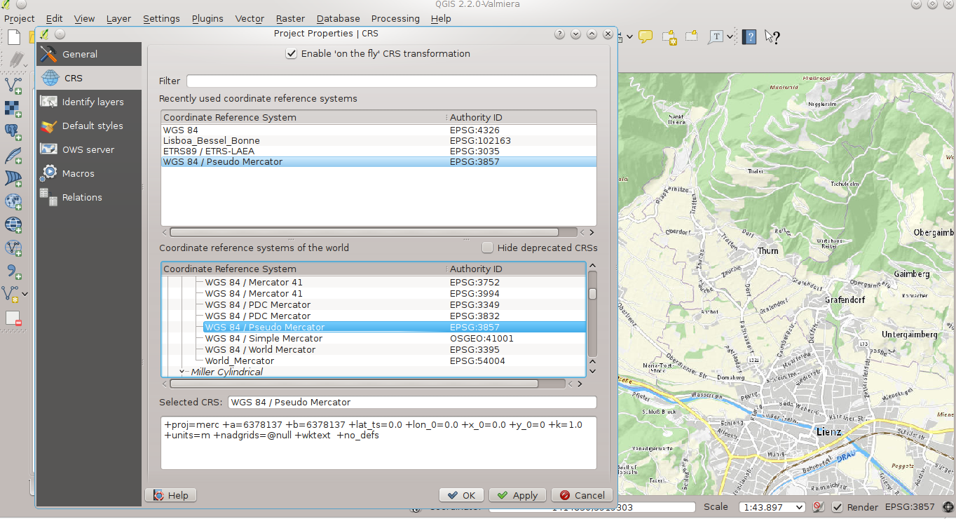
The Austrian govermental geodata-departments offer a free Basemap for Austria – Basemap.at (http://basemap.at/) – similar to GoogleMaps or OSM, based on official governmental data.
You can access this map via QGIS too – add a WMS/WMTS-Layer and use the following URL
http://www.basemap.at/wmts/1.0.0/WMTSCapabilities.xml

… for the best rendering-quality (no distortions) choose Google’s Pseudo Mercator as Project(Display)-CRS: EPSG 3857 (in QGIS 2.x: Settings – Project properties)
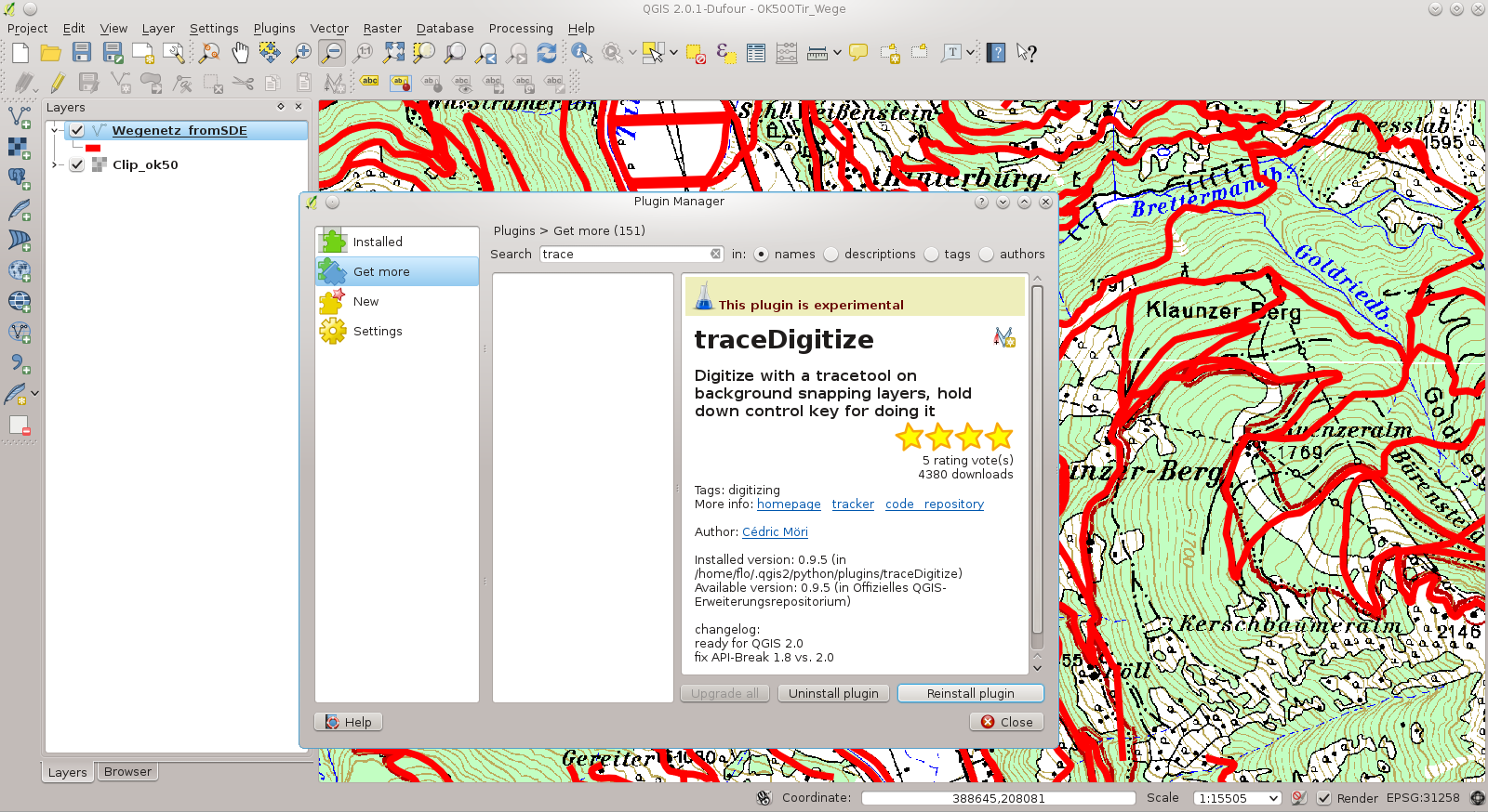
If you want to follow existing vector-geometry (trace it), the plug-in traceDigitize is very helpful. Please be keep in mind to set the Snapping-Tolerance (Settings – Snapping Options).