Some days ago we had a problem with an unwanted “Banner” on our WordPress-Blog – promoting slotmachines.us.org. It’s quite easy to find and get rid of the problem. But we did not find a lot of solutions online (mostly related to the Lightbox-PlugIn).
Ich hatte mal wieder ein Problem mit einem Linux-Server.
Dieser besaß eine statische IP-Adresse und wurde im Netzwerk über die Namensauflösung nicht gefunden. Ein anderer Linux-Rechner, der im Netzwerk mit DHCP eingebunden ist, konnte aber ohne Probleme über die Namensauflösung gefunden werde, was mit der Funktion DHCP to DNS zutun hat. Linux & DNS-Server – nsupdate weiterlesen →
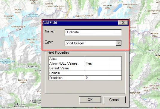
A short Python-Code in field-calculator will do the job – the result is in a new field with 0/1-values indicating if there is a duplicate for a given attribute.
Im GIS-Alltag kann es vorkommen, dass Geodaten aus dem eigenen Datenpool in diverse Tourenportale “wandern” müssen (zB Alpenverein aktiv etc.) – diese generieren dann Streckendaten wie Länge, Höhenunterschiede und Höhenprofile.
Manche dieser Systeme sind jedoch hinsichtlich “Datenimport” sehr heikel – als gängiges Format für den Import scheint sich GPX etabliert zu haben (2D oder 3D mit Höhenwerten).
Ich habe mich in letzter Zeit ein wenig mit der Programmiersprache Java beschäftigt. Das Ergebnis hiervon ist, dass ich das “8 Damen Problem” in Schach mit Java gelöst habe.
Was ist das “8 Damen Problem” in Schach?
Dies bedeutet, dass man 8 Damen auf einem Schachbrett so platzieren soll, dass keine Dame eine andere von Anfang an schlagen kann. Das Problem ist aber, dass die Dame folgendes darf: “Die Dame darf auf jedes freie Feld in jeder Richtung linear und diagonal ziehen, ohne jedoch über andere Figuren zu springen und vereint somit die Wirkung sowohl eines Turms als auch eines Läufers in sich.” Schach 8 Damen Problem mit Java weiterlesen →
Das NTv2-basierende Transformationsverfahren vom österr. Bundesmeldenetz (BMN / MGI) nach ETRS89 (und auch WGS84) ist nun auch mit den österr. Parametern des BEV (AT_GIS_GRID) in ArcGIS 10.2 “implementiert” – allerdings mit einem kleinem manuellen Eingriff.